Standing majestically in the Alaska Range, Mount Spurr is far more than just a picturesque peak; it is a formidable stratovolcano, a dynamic force of nature that commands respect and constant vigilance. Located west of Anchorage, Alaska's largest city, this prominent peak in the Aleutian volcanic chain has a storied history of eruptions, making it one of the most active volcanoes in the state. Understanding Mount Spurr is not merely an academic exercise for geologists; it is a vital aspect of public safety and preparedness for the hundreds of thousands of Alaskans living within its potential reach.
Named after USGS geologist Josiah Edward Spurr, this impressive stratovolcano (vnum #313040) is situated at 61°17'56 N 152°15'14 W, with its summit reaching an elevation of 11,070 feet (3,374 meters). Its proximity to a major population center, coupled with its active past, places it under constant scrutiny by the Alaska Volcano Observatory (AVO) and the Alaska Earthquake Center. From seismic rumblings deep beneath its surface to subtle changes in gas emissions, every sign of unrest is meticulously tracked, providing crucial insights into its potential behavior. This guide delves into the fascinating world of Mount Spurr, exploring its geological significance, its history of activity, the sophisticated monitoring systems in place, and, most importantly, how residents and visitors can prepare for and respond to a possible eruption.
Table of Contents
- Mount Spurr: A Geological Marvel
- A History of Fire: Mount Spurr's Eruptive Past
- Monitoring the Giant: The Science Behind Vigilance
- Signs of Unrest: What Happens When Mount Spurr Awakens?
- Preparing for the Unpredictable: A Community Guide
- Responding to an Eruption: Actionable Steps for Safety
- Visiting Mount Spurr: Adventure with Awareness
- Conclusion: Living with Alaska's Fiery Heart
Mount Spurr: A Geological Marvel
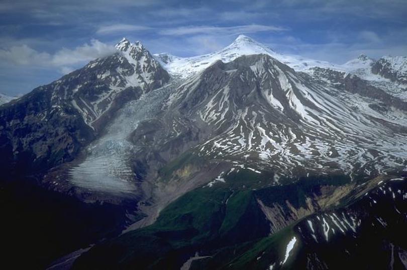
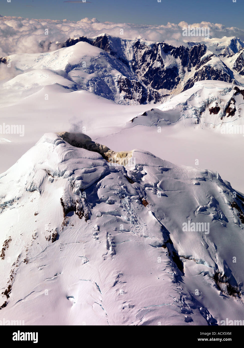
Mount Spurr is a classic example of a stratovolcano, characterized by its conical shape and steep slopes, built up by layers of hardened lava, tephra, pumice, and volcanic ash. It is a prominent feature of the Aleutian Arc, a chain of volcanoes formed by the subduction of the Pacific Plate beneath the North American Plate. This geological setting makes the entire region highly volcanically and seismically active. Unlike some seismic events that are purely tectonic, those associated with Mount Spurr are directly linked to the movement of magma, providing unique insights into the volcano's internal dynamics. What makes Mount Spurr particularly significant is its dual-summit structure. While the main summit reaches 11,070 feet, the volcano also features Crater Peak, a vent located two miles south of the main summit. Historically, this Crater Peak vent has been the site of Mount Spurr's most recent and notable eruptions, including those in 1953 and 1992. This distinction is crucial for monitoring efforts, as activity at Crater Peak often signals an impending eruption. The volcano stands as an active volcanic wonder within the Alaska Range, alongside other natural wonders of Alaska, attracting nature enthusiasts willing to face tough challenges for spectacular views.A History of Fire: Mount Spurr's Eruptive Past
Mount Spurr has a well-documented history of eruptions, serving as a stark reminder of its volatile nature. While geological records indicate numerous prehistoric eruptions, two periods of activity stand out in living memory: 1953 and 1992. These events not only shaped the volcano's landscape but also provided invaluable data for volcanologists and emergency planners.The 1953 Eruption
According to the Alaska Volcano Observatory, Mount Spurr erupted once in 1953. This event, originating from the Crater Peak vent, produced significant ashfall, impacting areas downwind. While less extensively documented than the later 1992 events, the 1953 eruption demonstrated Mount Spurr's capacity to disrupt local communities and aviation. It was a precursor to the more impactful events that would follow decades later, laying the groundwork for increased monitoring and preparedness efforts in the region.The 1992 Eruptions: A Modern Wake-Up Call
The year 1992 saw Mount Spurr erupt three times, all from the Crater Peak vent. These eruptions, occurring in June, August, and September, were particularly significant due to their proximity to Anchorage and the widespread distribution of volcanic ash. The August 1992 eruption, in particular, sent dangerous volcanic ash high into the atmosphere, causing significant disruption to air travel across the North Pacific and depositing ash over Anchorage and surrounding areas. This event highlighted the far-reaching consequences of a volcanic eruption, not just for local communities but also for global aviation and infrastructure. The ash, a fine abrasive powder, can damage aircraft engines, contaminate water supplies, and pose serious health risks. The experience of 1992 served as a crucial lesson for authorities and residents, underscoring the need for robust monitoring, effective communication, and comprehensive preparedness plans. For 268,000 Americans bracing for potential ashfall, the memory of 1992 is a powerful motivator for vigilance.Monitoring the Giant: The Science Behind Vigilance
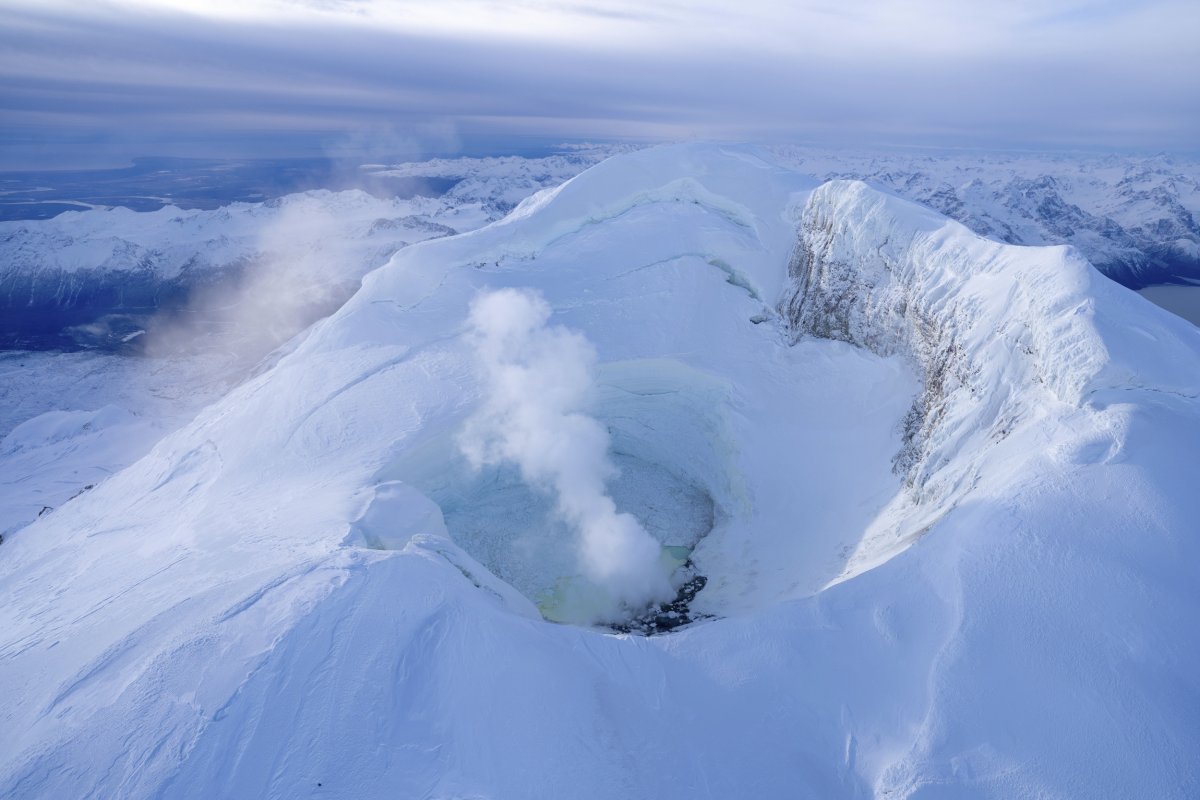
The unpredictable nature of volcanoes like Mount Spurr necessitates sophisticated and continuous monitoring. The Alaska Volcano Observatory (AVO) is at the forefront of these efforts, utilizing a comprehensive suite of tools to track even the most subtle changes beneath the volcano's surface. This dedication to monitoring is a cornerstone of the E-E-A-T principle, demonstrating the expertise and authoritativeness applied to public safety. Mount Spurr is monitored by a local seismic network, which detects and locates earthquakes. The Alaska Earthquake Center plays a crucial role in tracking seismic events associated with Mount Spurr, analyzing their patterns and how they differ from subduction zone earthquakes, which are typically deeper and caused by plate movement rather than magma. Maps and cross-sections of seismic activity help scientists visualize the movement of magma and stress within the volcano. Beyond seismicity, AVO employs other critical technologies: * **GNSS (GPS) Ground Deformation Stations:** These highly sensitive instruments measure changes in the volcano's shape, which can indicate magma moving upwards and inflating the ground. * **Infrasound Sensors:** These detect low-frequency sound waves generated by volcanic activity, such as gas emissions or explosions, even if they are imperceptible to the human ear. * **Web Cameras:** Providing real-time visual monitoring, these cameras allow scientists to observe changes in steam plumes, ice melt, or any surface activity. * **Gas Emission Sensors:** These instruments measure the type and quantity of gases being released from the volcano. Increased gas emissions, particularly sulfur dioxide, can be a strong indicator of new magma rising to the surface. Scientists have noted unusual gases being released from Mount Spurr for over a year, alongside earthquakes and ice melt, further emphasizing the need for close observation. The data collected from these diverse sources is continuously analyzed by experts at AVO. This integrated approach allows them to assess the current volcano alert level (currently "Advisory") and aviation color code, providing critical information for residents, visitors, and the aviation industry.Signs of Unrest: What Happens When Mount Spurr Awakens?
Volcanoes rarely erupt without warning. Instead, they typically exhibit a range of signs indicating increasing unrest. For Mount Spurr, these signs are meticulously tracked by the Alaska Volcano Observatory, providing crucial lead time for preparedness. Understanding these indicators is vital for public awareness and response.Magma Intrusion and Gas Emissions
One of the most significant indicators of potential eruption is the movement of magma beneath the volcano. The provided data indicates that Mount Spurr has been showing signs of new magma intrusion, with volcanic activity ramping up for months, revealing the intrusions of magma beneath the volcano. This rising magma can cause the ground to swell, detected by GPS stations, and can also lead to increased gas emissions. Mount Spurr volcano has been showing signs of increased gas emissions, particularly unusual gases, for over a year. These gases are often released as magma approaches the surface, and their composition and volume can provide clues about the magma's depth and type. An increase in gas emissions, especially sulfur dioxide, is a strong signal that an explosive eruption might be more likely in the next few weeks or months.Seismic Activity and Ground Deformation
Earthquakes are another primary indicator of volcanic unrest. The data notes that Mount Spurr has been shaking with earthquakes for over a year, and the activity has moved, suggesting magma migration within the volcano's plumbing system. These earthquakes are often shallow and can occur in swarms, indicating the fracturing of rock as magma forces its way upwards. Ground deformation, measured by GNSS (GPS) stations, provides direct evidence of the volcano swelling or deflating due to magma movement. When magma intrudes, it pushes the surrounding rock, causing the ground surface to deform. Conversely, if magma retreats, the ground may subside. Scientists closely monitor these changes, as they provide a spatial and temporal understanding of magma's journey towards the surface. While there was a period when experts noted an increased likelihood of eruption in the next few weeks or months, a more recent information statement from May 28th, 2025, summarized that the magma intrusion beneath Mount Spurr has stalled, and the likelihood of an eruption continues to gradually decline. This highlights the dynamic nature of volcanic systems and the importance of up-to-date information from AVO.Preparing for the Unpredictable: A Community Guide
Given Mount Spurr's history and its proximity to Anchorage, preparedness is not just recommended; it's essential. A guide for residents and visitors of Alaska to prepare for and respond to a possible eruption of Mount Spurr volcano is a critical component of public safety, aligning perfectly with YMYL principles. The primary hazard from Mount Spurr, particularly for populated areas, is volcanic ash. Here are key steps for preparedness: * **Stay Informed:** Regularly check updates from the Alaska Volcano Observatory (AVO) and local emergency management agencies. Understand the current volcano alert level and aviation color code. These resources are designed to provide timely and accurate information. * **Develop a Family Emergency Plan:** Discuss what to do in case of an eruption. Identify meeting points, communication strategies (since cell service might be disrupted), and out-of-state contacts. * **Prepare an Emergency Kit:** This kit should include: * **Respiratory Protection:** N95 masks or other respirators to protect against ash inhalation. * **Eye Protection:** Goggles or eyeglasses (not contact lenses) to shield eyes from irritation. * **Water:** At least a 3-day supply per person, as ash can contaminate water sources. * **Food:** Non-perishable food for at least 3 days. * **First Aid Kit:** Essential medications and supplies. * **Flashlight and Batteries:** For power outages. * **Radio:** Battery-powered or hand-cranked radio to receive emergency broadcasts. * **Dusting Tools:** Brooms, shovels, and plastic sheeting for ash removal. * **Important Documents:** Copies of vital records in a waterproof bag. * **Protect Your Home and Property:** * Seal windows and doors to prevent ash intrusion. * Cover sensitive equipment, including computers and vehicles. * Disconnect downspouts to prevent ash from entering drainage systems. * Be aware that heavy ashfall can collapse roofs. * **Protect Your Vehicle:** Keep gas tanks full. If ash is falling, avoid driving as ash can damage engines, clog air filters, and reduce visibility. If you must drive, proceed slowly. * **Know Your Evacuation Routes:** While ashfall is the primary concern, in rare cases, other hazards like lahars (volcanic mudflows) could pose a threat to areas closer to the volcano. Understand local evacuation plans. The guide provides links to local and national resources on volcano monitoring, emphasizing the importance of accessing official and trustworthy information.Responding to an Eruption: Actionable Steps for Safety
If Mount Spurr erupts and ashfall is anticipated or occurring, swift and informed action is crucial for personal safety and minimizing damage. The actions taken during an eruption can significantly impact health and property. * **Stay Indoors:** The most important step during ashfall is to remain indoors. Volcanic ash consists of tiny, sharp glass particles that can irritate the eyes, skin, and respiratory system. * **Protect Your Breathing:** If you must go outside, wear an N95 mask or a damp cloth over your mouth and nose to filter out ash particles. Protect your eyes with goggles. * **Protect Your Water Supply:** Disconnect downspouts to prevent ash from entering rain barrels or cisterns. If you rely on well water, ensure the wellhead is sealed to prevent contamination. * **Clear Ash Safely:** Ash is heavy, especially when wet, and can accumulate on roofs, leading to collapse. * Wait until ashfall has stopped before clearing. * Wear protective gear (mask, goggles, long sleeves). * Shovel ash carefully, starting from the center of the roof and working outwards. * Do not put ash into storm drains, as it can clog them and cause flooding. Bag it or place it in designated areas. * **Avoid Driving:** Volcanic ash significantly reduces visibility, clogs air filters, and can damage engines. If you must drive, do so slowly, use headlights, and keep windows closed. * **Listen to Authorities:** Pay close attention to official broadcasts from AVO, NOAA Weather Radio, and local emergency services for updates and specific instructions. * **Be Mindful of Lahars:** While ashfall is widespread, areas closer to the volcano, particularly along river valleys originating from Mount Spurr, are susceptible to lahars. These fast-moving mudflows can be triggered by eruptions melting snow and ice. If you are in a low-lying area near a river, be prepared to move to higher ground quickly. The chance of Alaska’s Spurr volcano erupting can fluctuate, but the caveat remains: the last time Mount Spurr erupted, it sent dangerous volcanic ash over a wide area. Preparedness and a calm, informed response are the best defenses.Visiting Mount Spurr: Adventure with Awareness
For nature enthusiasts and adventurers, Mount Spurr offers spectacular views of glaciers, forests, and wildlife, standing as a testament to Alaska's rugged beauty. However, visiting an active volcano requires a heightened sense of awareness and adherence to safety guidelines. * **Best Routes and Seasons:** Access to Mount Spurr is challenging and often involves remote travel. Research the best routes, which typically involve air taxi or experienced guides, and consider the best seasons for travel, usually summer months when conditions are more favorable. * **Activities:** Activities around Mount Spurr can include mountaineering, hiking, and wildlife viewing. The area is home to diverse Alaskan fauna and flora, offering unique photographic opportunities. * **Safety Tips:** * **Inform Others:** Always inform someone of your itinerary, including your planned route and return time. * **Carry Emergency Gear:** Beyond standard hiking gear, consider carrying a satellite phone or inReach device for emergency communication. * **Monitor Volcanic Activity:** Before and during your trip, continuously check the Alaska Volcano Observatory for any changes in the volcano's alert level. If the alert level is raised, or if you observe any unusual activity (e.g., strong sulfur smells, increased steaming, ground shaking), evacuate the area immediately. * **Respect the Environment:** Stay on marked trails where available, pack out all trash, and respect wildlife. * **Be Prepared for Weather:** Alaskan weather can change rapidly. Bring layers of clothing, rain gear, and sufficient food and water. While Mount Spurr attracts those willing to face tough challenges, the primary focus should always be on safety and respecting the immense power of this natural wonder. Its two summits offer unique perspectives, but only from a safe and informed distance.Conclusion: Living with Alaska's Fiery Heart
Mount Spurr stands as a powerful symbol of Alaska's dynamic geological landscape. From its towering summit and dual peaks to its history of explosive eruptions, it is a volcano that demands our attention and respect. Monitored meticulously by the Alaska Volcano Observatory and the Alaska Earthquake Center, every tremor, gas emission, and ground deformation is analyzed to provide the most accurate assessment of its current state. While the likelihood of an immediate eruption can fluctuate, as evidenced by the recent information statement indicating a decline in magma intrusion, the potential for future activity always remains. For residents and visitors of Alaska, understanding Mount Spurr is not just about geological curiosity; it's about personal and community safety. The lessons learned from the 1953 and 1992 eruptions, particularly the widespread impact of volcanic ash, underscore the critical importance of preparedness. By staying informed, having an emergency plan, and knowing how to respond to ashfall, Alaskans can significantly mitigate the risks associated with living near this active giant. Whether you are an adventurer seeking its majestic views or a resident living in its shadow, Mount Spurr reminds us of the raw power of nature and the ongoing need for vigilance and preparedness. We encourage you to share your thoughts or experiences with Mount Spurr in the comments below. Have you been impacted by a volcanic ashfall, or do you have tips for preparedness? Your insights can help others in the community. For more information on volcanic activity in Alaska and how to stay safe, explore other articles on our site and consult official resources like the Alaska Volcano Observatory website.Related Resources:
Detail Author:
- Name : Althea Padberg
- Username : bode.daisy
- Email : yasmeen38@hotmail.com
- Birthdate : 1987-02-20
- Address : 383 Lorenz Crest North Amiyaburgh, TN 02911
- Phone : 743.990.2236
- Company : Schiller, Gutkowski and Jones
- Job : Immigration Inspector OR Customs Inspector
- Bio : Minus provident repellendus dignissimos sed. Aut maiores molestiae fugiat eum. Quos laboriosam maxime molestiae perspiciatis voluptatem doloremque modi.
Socials
twitter:
- url : https://twitter.com/tillmanc
- username : tillmanc
- bio : Sint magni eos ab et quia ex. Officia saepe sit reprehenderit aliquid nisi.
- followers : 692
- following : 763
linkedin:
- url : https://linkedin.com/in/colleen_official
- username : colleen_official
- bio : Blanditiis quo soluta voluptatem.
- followers : 5959
- following : 2157
